|
Explore JTR
- Maps
|
|
|
Explore JTR
- Maps
|
|
|
[Area Map]
[Description]
[Detail Map]
|
|
|
|
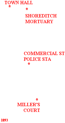
See map on right for location of Shoreditch mortuary and Town Hall and how it relates to Dorset Street and Commercial Street Police Station. |
DESCRIPTION
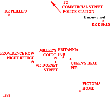
Dorset St ran east-west from Commercial St to Crispin St. At the Commercial St end it faced the churchyard of Christ Church, Spitalfields an area sometimes known as Itchy Park. Opposite the western end stood the Providence Row Night Refuge and Convent at 50 Crispin St, Dorset St was quite a narrow thoroughfare and was about 130 yards long. It was flanked by old, brick-built properties, probably dating from the early eighteenth century, whose doors opened directly to the street.
Dorset St's properties were numbered consecutively along the south side from west to east (1-20) and back along the north side from east to west (21-39). Guarding either end on the north side were 2 pubs. The 3-story Britannia (aka Ringer’s after its landlady, Matilda Ringer) was actually #87 Commercial St, at the eastern end, whilst the similarly imposing Horn Of Plenty, (officially #5 Crispin St, landlord Christopher Brown) was at the western end. 3 alleyways ran out of the northern side of Dorset St: Paternoster Row, which lay between #35 & #36 ran all the way into Brushfield St, exiting alongside the Oxford Arms pub. It contained several common-lodging houses. The others were New Court and Miller's Court, both of which contained low-grade housing. New Court was almost mid-street, its narrow entry located between #33 & #34. The narrow entrance to Miller's Court was about a quarter of the way along the street from the eastern end, nestling between #26 & #27, both of which were owned by a grocer and slum property landlord, John McCarthy. Whilst McCarthy resided at #27 and carried on his chandler's business from its ground floor shop, #26 was being used as a storeroom at the time of the murder.
A pub called the Blue Coat Boy (William James Turner) stood at #32. 2 other chandlers provided competition to McCarthy, Barnett Price at #7 and Alfred Coates at #36. A feature of the locality was the 'slum landlord' who owned or rented a number of cheap properties. Coates, for instance, also had a common lodging house in Flower & Dean St. In addition to his shops, John McCarthy was also the landlord of the properties in Miller's Court (aka McCarthy's Rents or McCarthy's Court). In 1890, his brother Daniel took over the shop at #36. Eventually John McCarthy acquired the common lodging house at #30, one of many such houses in Dorset St.
Two large lodging houses were known as Crossingham's after their owner, William Crossingham; namely #35 where Annie Chapman had lodged and #17 opposite the entrance to Miller's Court. Other known lodging houses at the time were nos. 9, 10, 11-12 and 28-29. In all about 750 beds were provided in Dorset St, officially (though the rules were flouted widely and in practice there would have been many more).
Most of the properties that were not registered lodging houses were rented out to tenants on a room by room basis. There is little evidence of other businesses being conducted from Dorset St. in the 1880s, but in the years following we see two milk contractors listed (at #13A & #14A by Messrs William Wright & Amos Payne) and a coal dealer, Mrs Jane Brooks from #39. Since the Brooks family was resident at #39 by 1881 there is a good chance that the business was operational much earlier than its listing in Kelly’s Directory.
Dorset Street possessed a bad reputation. It was renowned for its poverty and crime. Being part of what the Rev. Barnett called the "wicked quarter mile", it fell within H-Division of the Metropolitan Police and was one of the streets that was double patrolled. Charles Booth, an early sociologist who surveyed London, produced his poverty map in 1887, colour coding the different streets of the metropolis. Dorset Street achieved the lowest ranking, shaded black and described as vicious and semi-criminal.
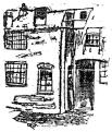
Miller's Court was approached from Dorset St. via a flagged passage that ran under an arch. Little more than a yard wide, it was about twenty feet long. The door to Room 13 was the last on the right before the passage opened out into a yard about fifteen feet square. The yard contained a water tap and a communal dustbin. There was no other access to #13, which had been partitioned off from the back of 26 Dorset St. The two windows of #13 looked out into the yard. Along the left-hand side of Miller's Court the passage extended beyond the yard for a further forty feet, here being about ten feet wide. It was flanked by lines of two-story, 'one up, one down' slum houses, built of brick. Miller’s Court had 2 units on the left, (the last not being used as accommodation) and 3 on the right. Numbering started with #1, downstairs on the left, with #2 above it, running down the left side and back up on the right such that #12 was upstairs, nearest to Mary's window. The houses were all whitewashed at ground floor level. Light was provided by a gas lamp mounted on the wall outside #1.
Miller’s Court was built at a time when there was increasing pressure on the district’s housing: it would have been slum housing from the start. The name Miller’s Court first appears in the census of 1861, building thus having been completed in the 1850s. However, the 1851 census has three dwellings in a place named Miller’s Rents in Spitalfields, listed after Dorset St. and New Court and immediately before Paternoster Row. This virtually confirms its existence as the same place.
Dorset St. was renamed Duval Street in 1904. Its north side including Miller’s Court was demolished in the late 1920s when Spitalfields Market was extended.

|

|
|
1. 26 Dorset St (Store room owned by McCarthy) 2. Miller's Court (also know as McCarthy's Rents) 3. John McCarthy's Chandler Shop (27 Dorset St) 4. Blue Coat Boy Pub (32 Dorset St) 5. New Court 6. 35 Dorset St (Crossingham's Lodging-house Annie Chapman's residence) 7. Paternoster Row |
8. Alfred Coates Chandler Shop (36 Dorset St) 9. Horn of Plenty Pub (5 Crispin St) 10. Providence Row Night Refuge (50 Crispin St) 11. 17 Dorset St (Crossingham's Lodging-house) 12. The Queens Head Pub (74 Commercial St) 13. The Britannia Pub (87 Commercial St also known as Ringers) |
14. Mary Jane Kelly's Room (13 Miller's Court, murder scene) 15. Julia Vantourney (1 Miller's Court) 16. Sara Lewis (The Kyler's) (2 Miller's Court, above Julia Venturney's room) 17. Mrs Mary Ann Cox (5 Miller's Court) 18. Mrs Elizabeth Prater (20 Miller's Court, above Mary Jane's room) 19. Dustbin |
For sources used, refer to the Time Line of the specific victim.
Many THANKS to the people who have contributed to this page:
Geographical assistance - Courtesy of The Viper.
Miller's Court image - Courtesy of New York Herald.
Pub addresses - Courtesy of Ripperologist, issue #22.
Miller's Court detail - Redrawn from Daily Telegraph via Alex Chisholm.
93 area map extract - Courtesy of Godfrey's Ordnance Maps via The Viper.
94 detail map extract - Courtesy of Godfrey's Ordnance Maps via The Viper.
88 area map extract - Courtesy of G. Bacon's New Large-Scale Ordnance Atlas.